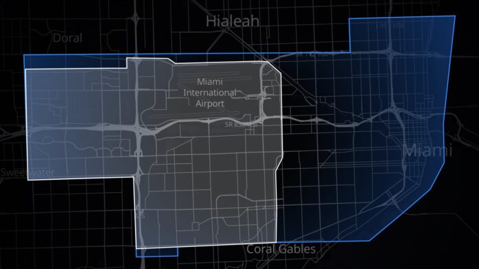

Tesla’s Robotaxi just got a lot more useful in Miami. The service area there has nearly doubled overnight, pushing east from the airport district all the way to downtown and the edge of Biscayne Bay. Tesla didn’t publish a new size, but community trackers that measure each map put it at about 59 square miles (roughly 152 km²), up from about 31.
The official @robotaxi account announced it with a single line, “Now serving more of Miami,” and a map with the old zone outlined in white and the new one in blue. It went up at 2:44 AM ET on Monday, Nov. 16 (11:44 PM PT Sunday, Nov. 15), which was 4:44 PM JST Monday.
What the new map covers
The old Miami zone was a suburban rectangle built around Miami International Airport, stretching west toward Doral and Sweetwater and south to the edge of Coral Gables. Useful for an airport run. Not much use if your day happens downtown.
The blue zone fixes that. It runs east past the airport to downtown Miami and down the bay shore, and it adds a strip to the north near State Road 112 and I-95. Robotaxi Tracker logged the change as a 28-square-mile gain, or 92.4%, to about 59 square miles. EVwire traced the same map more conservatively and came up with roughly 50 square miles, nearly double its own estimate of the old zone. Both are estimates from a picture, and both say the same thing. The map about doubled.
Tracker readings of the map also place Brickell, Little Havana and Wynwood inside the new line. Miami Beach is still outside. The blue zone stops at the western shore of the bay.
The second Miami expansion in about three weeks
Miami opened on July 3 as Tesla’s first Robotaxi city in Florida, with a modest zone west of downtown. By late October, when Tesla watcher Sawyer Merritt shared square-mile figures for every city, Miami had reached 31 square miles, Benzinga reported. In that same thread, when asked why the Miami and Tampa zones skipped the beaches, Elon Musk replied “Coming soon.” The beaches still aren’t in. Downtown came first.
That order makes sense. Downtown Miami is where trips start and end: offices, hotels, the cruise port’s neighborhood, the Brickell towers. It’s also harder driving, with dense traffic, tight curbside pickups and a lot of pedestrians. Adding it tells you Tesla is comfortable with the software in a busier environment than the airport grid.
It also fits a pattern from the past month. Tesla launched San Antonio on Nov. 9 with a 275-square-mile day-one map, its largest launch yet, and three days later made rides available 24/7 in all eight cities: Austin, Dallas, Fort Worth, Houston and San Antonio in Texas, plus Miami, Orlando and Tampa in Florida. Bigger maps, longer hours. Same direction every week.
Why Cybercab buyers should care
There’s a second audience for this map. On Nov. 13, Tesla started inviting select customers to buy a Cybercab for personal use at $29,990, plus a required Autonomy Subscription Tesla lists at $299 a month. Tesla says the car works only in “supported service areas,” and AI software chief Ashok Elluswamy said it will run unsupervised “inside all the same geo locations as @robotaxi.” For now, the order page’s delivery menu lists only five Texas cities. If Florida deliveries open later, a Miami owner’s car will only go where this map goes. So every square mile added here is also a square mile a future owner can use.
Miami is also a head-to-head market. Waymo already runs driverless rides in the city, and Tesla’s push downtown puts the two services on the same streets. Tesla runs the Model Y with its camera-based FSD software, while Waymo uses a lidar-equipped fleet. Riders in Brickell can now compare them directly.
The fine print hasn’t changed. A trip still has to start and end inside the zone, and wait times depend on how many cars Tesla puts on the larger map. Tesla hasn’t said how big its Miami fleet is.
The EVX Take
Size is easy to put in perspective from Tokyo. At about 152 km², the new Miami zone is roughly a quarter of the area of Tokyo’s 23 wards (about 627 km²). That’s the scale of service Tesla now runs, driverless and around the clock, in one of eight cities. Japan’s closest equivalent is still on the calendar. Waymo, Nihon Kotsu and GO are aiming for a driverless taxi service in Tokyo in 2027, and Toyota will build bZ4X robotaxis for Waymo in Japan starting the same year. Tesla hasn’t given a Japan Robotaxi timeline, and FSD (Supervised) still isn’t approved here. When Japanese regulators sit down to decide how big a first driverless zone should be, a Miami map that doubled in three weeks with downtown included is a useful data point.
Sources: Robotaxi (@robotaxi, Tesla) on X; Robotaxi Tracker; EVwire; Benzinga; Tesla Cybercab order page and invitation as reported on Nov. 13–14. Featured image: Tesla’s Miami Robotaxi geofence map, old zone in white and new zone in blue. Image: Tesla (@robotaxi on X) (cropped).

